Navionics NAPC029R - New Zealand - Navionics+
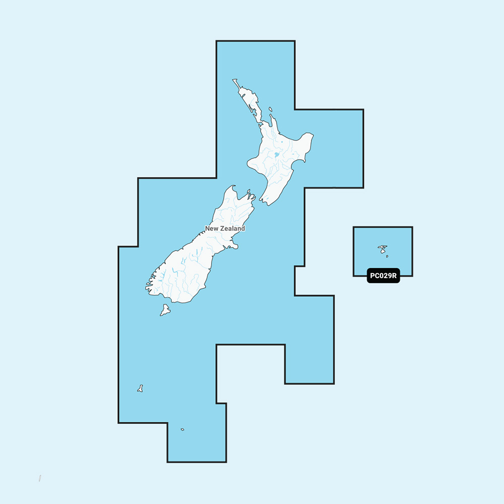
NAPC029R - New Zealand - Navionics+
Get the world’s No. 1 choice in marine mapping - with the best, most up-to-date Navionics+ cartography on your compatible chartplotter.
For offshore or inland waters, this all-in-one solution offers detail-rich integrated mapping of coastal waters, lakes, rivers, and more. Get SonarChart™ 1’ (0.5 meters) HD bathymetry maps, advanced features such as dock-to-dock route guidance technology, live mapping, and Plotter Sync to provide wireless access to daily updates.
The Navionics Chart Installer software also ensures the freshest chart data every time. Navionics dock-to-dock route guidance solutions suggest a path to follow through channels, inlets, marina entrances, and more. Multiple shading options aid in shallow water navigation and make it easy to highlight a target depth range for the best fishing spots.
Chart Code - NAPC029R
Coverage Area:
Detailed coverage of both North and South Island in their entirety. Coverage includes the Chatham Islands, the Bounty Islands, the Campbell Islands, and the Auckland Islands.
Features:
- Nautical Chart – Comprehensive charts are derived from multiple officials, government, and private sources, displayed in a familiar look and feel
- Coastal Content - Offers detail-rich integrated mapping of coastal waters, lakes, rivers, and more
- Inland Content - 44,000+ lakes
- Community Edits - Get useful local knowledge from edits made by users of the Navionics Boating app on your compatible smart device.
- Daily Updates1 - Up to 5,000 daily updates to our charts give you the most accurate, most current Navionics data available
- Dock-to-dock Route Guidance1,2 - Start your trip with a suggested path
- SonarChart Live Mapping3 - Watch new HD depth maps develop in real-time as your boat moves through the water.
- Advanced Map Options1 - Customize your view to focus on the details that matter most
- Plotter Sync1 - Transfer routes and markers, update chart layers, and more - between your compatible chartplotter and the Boating app.
Compatibility:
- Check the compatibility of Navionics+ content and features with your GPS chartplotter.
Technical Specifications:
- Format - SD/MSD Card
In the Box:
- SD/MSD Card
1Subscription not required for SonarChart Live mapping feature on some chartplotter models; requires latest chartplotter firmware release.
2Dock-to-dock Route Guidance is for planning purposes only and does not replace safe navigation operations.
*Sold as an Individual
*Navionics+ and Platinum+ cards are not compatible with Garmin chartplotters.
This product may not be returned to the original point of purchase. Please get in touch with the manufacturer directly with any issues or concerns.
This product may not be returned to the original point of purchase. Please contact the manufacturer directly with any issues or concerns.Large In-Stock Inventory
With over 18,000 products in stock and our ability to leverage relationships with over 300 manufacturers that other distributors don't have, CWR Wholesale Distribution can offer you the best inventory at the best prices year round. No hassle.
Top Selling Navionics Products

CWR's Facilities
With two large facilities and a partnership with over 300 brands in the marine and outdoor industries, CWR’s selection and service cannot be beat. We have an inventory with over 18,000 unique products in stock, ready to ship, and at a competitive wholesale price.
Become a CWR dealer and get:
- Wholesale pricing from over 300 brands
- No minimum order
- Flat rate shipping as low as $9.95
- Free FTP and website integration
BECOME A DEALER